 Job Description
The Okinawa Institute of Science and Technology is seeking candidates for a Remote Sensing (RS) and Geographic Information System (GIS) Specialist. The RS & GIS Specialist will help build GIS capacity at the university, support analysis of various spatial datasets to assess forest change and help in the collection and management of biodiversity and environmental data. Responsibilities
2. Conducting digital mapping, land use/land cover mapping based on remote sensing data using digital technologies
Qualifications
Salary and Benefits The appointment is initially for one year with possibility of renewal. Salary is commensurate with experience and skills. Applications, including a cover letter (in English), copy of a CV, and the names and addresses of three referees, should be sent by email to [email protected]. Informal inquiries are welcome via email. About OIST The Okinawa Institute of Science and Technology (www.oist.jp) is a new interdisciplinary research institute and graduate university located in the beautiful seaside village of Onna-son, adjacent to coral reefs and subtropical forest. The institute is international by design; the working language is English and researchers are split between Japanese and foreign nationalities. Knowledge of Japanese is not required, and our relocation staff will assist you with moving to Okinawa and setting up your life. For more information on OIST, see recent articles in Nature (http://www.nature.com/news/2011/110629/full/474553a.html) (http://www.nature.com/nature/journal/v474/n7353/full/474541b.html), the Economist(http://www.economist.com/node/21540228).  Position: Acquisition Intern
Level: Intern Status: Part-time or full-time Reports Directly To: Acquisition lead Quantum Spatial is in search of an Acquisition Intern in the Portland office. We are looking to fill this position immediately. This job will initially be a part-time position (20+ hours a week), with the potential for full-time capacity based upon work load and availability. Description The acquisition intern will work under the supervision of the Portland acquisition team in support of field data collection operations. This position will provide an opportunity to learn first-hand the principles behind remote sensing data acquisition, including collection of LiDAR and orthophotography. There will also be opportunities for hands-on training in ground survey methodology in support of flight operations. This is a chance to gain real world experience in a fast-paced business environment in one of today’s fastest growing industries. Required Qualifications A successful candidate will have the following: • A valid driver’s license and clean driving record • Proficiency in Microsoft Excel • Understanding of basic GIS principles and geospatial concepts • Familiarity with ArcGIS software • Current enrollment or a degree from an accredited university in science, engineering, or a related field Duties and Responsibilities • Provide support organizing daily field log data • Assist in project status tracking • Organization and distribution of supplies to field staff • Perform initial QC checks of raw data from the field • Travel as needed in order to assist in field operations Knowledge, Skills, and Abilities We are looking for individuals with the ability to be successful working independently, as well as in a team setting. The ideal candidate is self-motivated with excellent decision making and problem solving abilities, computer proficiency, and an interest in GIS and remote sensing. The ideal candidate should possess the desire and flexibility to work in a fast-paced, dynamic work environment. Physical Demands and Work Environment A typical work day for an acquisition intern can be broken down as follows: • 70% office related tasks involving time spent at a computer • 20% walking, running errands, and organization of field supplies • 10% moving equipment up to 50 pounds • Occasional travel and field work may be required (field work is outdoors and may involve inclement weather and rough terrain) It is the policy of Quantum Spatial to provide equal opportunity for all qualified persons and not to discriminate against any employee or applicant for employment because of race, color, religion, sex, age, national origin, sexual orientation, veteran status, disability, or any other protected status. Resumes will be accepted until all positions are filled. Immediate submissions are welcome and will be reviewed promptly. All job offers with Quantum Spatial are contingent upon passing a background check and drug screening. How to Apply: Please upload a letter of interest, resume with professional references, and salary history in one (1) PDF via online application https://workforcenow.adp.com/jobs/apply/posting.html?client=wsidata&jobI... No phone calls, please. Incomplete applications and auto-reply submissions will not be considered. WSI is now Quantum Spatial. Read all about it here.  PROJECT LEAD
Quantum Spatial, Corvallis, Oregon Closes: Open Until Filled; Application reviewed as received Quantum Spatial (formerly WSI, Watershed Sciences Inc) is hiring. This position works directly under the supervision of the Process Operations Manager and Senior Scientists to lead and coordinate all processing (post-calibration) classification, QA/QC, deliverable production, reporting, and delivery to clients. Client and partner interactions should be expected. This position is broad enough to allow for areas of specialization within the Project Leads (LiDAR, Photo, Feature Extraction, etc) and will require learning methods associated with new products developed at QSI. Looking for someone with an expressed commitment to a career in remote sensing and geodetics. Complete job description and on-line application process are available at: http://www.watershedsciences.com/about/jobs/project-lead-1 No phone calls, please. Incomplete applications and auto-reply submissions will not be considered.  NASA Remote Sensing Data for Land Resources Management.
May 20 – June 17 2014 Every Tuesday, 5 webinars: one hour per week 12 noon, Eastern Daylight Time (EDT) To Register go to: https://attendee.gototraining.com/r/4845575589179714049 or http://water.gsfc.nasa.gov Course Objectives: •Provide an overview of freely available NASA Earth science data and web-tools for decision making and land resources management at regional to global scales. •The course will help professionals assess which NASA data and decision support tools are best suited to their environmental management needs. Course Participation: This course is intended for land resources managers, NGOs, international development agencies, and private sector organizations. Space is limited, preference will be given to these and other environmental professionals. Certificates provided upon request to those who attend all 5 webinars and complete the homework assignments For more information contact: [email protected] or [email protected]  Position: Remote Sensing Imagery Scientist
Level: Lead Reports Directly To: Director of IT Quantum Spatial is in search of a full-time Remote Sensing Imagery Scientist in the Portland office. We are looking to fill this position immediately. Description The remote sensing imagery scientist will work with the R&D team to develop, implement and manage solutions for imagery data obtained from remote sensing platforms to obtain meaningful results. The ability to work across divisional groups and integrate imagery solutions into existing and future production workflows will play a significant role in achieving success. For full job description and application details: http://www.earthworks-jobs.com/rsgis/quantumspatial14041.html  Dr. Gatziolis will give a talk on GIS/remote sensing processing in R. The presentation will be held on Wednesday, April 9, 11 am at the large conference room on the 4th floor of the Gus Solomon building, located at 620 SW Main Street. The talk is open to the public.
 REMOTE SENSING ANALYST
Quantum Spatial, Anchorage, Alaska Closes: Open Until Filled Quantum Spatial Anchorage is in search of applicants to fill 2 full-time Remote Sensing Analyst positions. This position works to complete CADD, GIS, image production and reporting tasks. Depending on the diversity and number of active projects, the Remote Sensing Analyst position may or may not be assigned to a single project. It is expected that areas of specialty may develop within this position. The successful candidate should expect to be challenged both technically and with the breadth of tasks inherent to the position. This position requires a bachelor’s degree or higher in science, engineering, or a related field, and 2-3 years of relevant experience in remote sensing data processing. Necessary skills include: general understanding of production and quality control methodologies, excellent communication, technical proficiency with multiple software packages, the ability to balance competing priorities, and the ability to work well with a team. Resumes will be accepted until all positions are filled. Immediate submissions are welcome and will be reviewed promptly. Complete job description and application instructions are available at: http://quantumspatial.com/news/careers  The PSU Geospatial Information Society is hosting a colloquium on Friday, 7 Mar, from 3:00 to 4:00 PM in Cramer Hall room 413.
Our speaker will be Erin Stockenberg from the US Fish & Wildlife Service. She will be speaking about using high-resolution LiDAR to model the hydrography of Wapato Lake, near Gaston, OR. All are welcome, and we invite you to join us for this presentation. Please share the flyer with anyone else you know who might be interested in attending.  The PSU Geospatial Information Society is hosting a colloquium this Friday, 31 Jan, from 3:00 to 4:00 PM in Cramer Hall room 413.
Our speaker will be Angie Diefenbach, a geologist with USGS-USAID Volcano Disaster Assistance Program at the Cascades Volcano Observatory in Vancouver, WA. Her presentation will focus on using oblique photogrammetry as a tool to monitor active volcanoes. All are welcome. Please see the attached flyer for details. 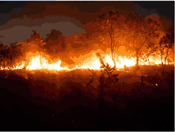 Graduate Student Research Assistantships Available for an NSF Funded Research Project on Fire in Africa
We have 2 positions available for two years of funding for our Masters program in Geography at CSU, Long Beach. Spring Admission Deadline: October 31st Position 1. Remote Sensing: The ideal candidate will have experience with remote sensing/ image processing software such as ERDAS or ENVI or e-cognition software. The research will involve mapping savanna vegetation cover and fire scars. Position 2. GIS spatial analysis: The ideal candidate will have experience with environmental GIS applications using ESRI spatial analyst software. The research will involve mapping savanna vegetation and fire scar patterns and changes. For more information contact: Dr. Paul Laris Chair of Geography California State University , Long Beach [email protected] |
Categories
All
Archives
June 2024
|
 RSS Feed